
Rangitoto Station walking tracks

Walking Tracks & Roads
There are a number of excellent walking tracks and four formed gravel roads around the reserve. 4WD is recommended for all roads.
PLEASE NOTE: Rangitoto Station is a remote, high-altitude site with rough walking underfoot and quickly changing weather conditions. We highly recommend that all users carry a Personal Locator Beacon (PLB) at all times.
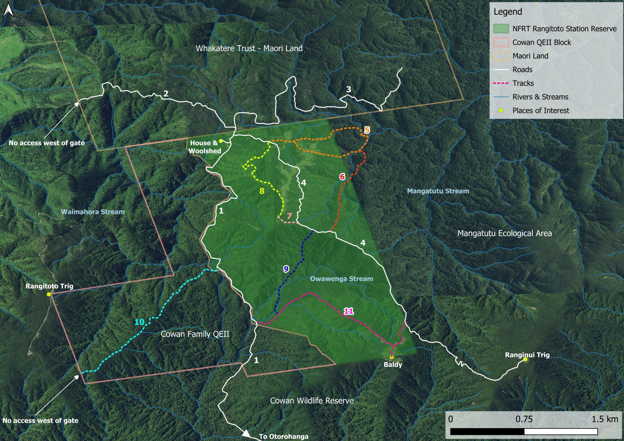
- Owawenga Road: Main access road into Rangitoto from Otorohanga that you drove in on (labelled Rangitoto Walk by the woolshed). Comes in via DOC’s Cowan Wildlife Refuge and the Cowan Family QEII block. To hear the kokako in the Cowan Wildlife Reserve, continue on past the locked entrance gate you came in through.
- Spotlight Gate Road: Well-formed road through the Whakatere Trust Maori Land. Locked gate at western end, so if driving, turn around at quarry, there is no turning area at gate.
- Rimu Road: Well-formed driveable road, with turnaround area at the eastern end. Great track for kokako listening and spotting.
- Ranginui Trig Road: Begins just north of the house & woolshed. To the east is the Mangatutu Ecological Area. As you drive further up towards Ranginui Trig, there are views to the west down the Owawenga valley. Excellent views and interesting vegetation (Dracophyllum) at the Trig. From the intersection with (6) the road becomes much steeper (4 hours or more return walking, 25 minute drive).
- Mangatutu Track: Begins at signpost on left along Ranginui Trig Road about 15 minutes from the house. Goes through excellent kokako territory (about 3 hours return walking from house).
- Mangatutu Extension: From Mangatutu Stream back up to Ranginui Trig Road (up to 6 hours return walking from house).
- Zigzag Track: very short track off Ranginui Road to the Airstrip (10 min walk).
- Airstrip Track: On the right past the stream on the Ranginui Trig Road and about 10 minutes from the house. The quickest route up to the airstrip is past the Woolshed and straight up the hill to meet with the Airstrip Track (30 minutes walking).
- Saddle Track: Poorly marked bush track for trampers. Sign-posted. The start is from the saddle along from the quarry, south of the airstrip. Connects with (11). A magnificent rimu a few seconds in, and good bird life (robins). Caution: this track is rough and not regularly maintained (3 hours or more walking one-way).
- Rangitoto Track: Is signposted on the right about 30 minutes from the house along Owawenga Track. This old 4WD track leads up through attractive regenerating bush on Cowans’ QEII covenanted land, towards Rangitoto Trig. There is a locked gate at the western boundary of the Cowan QEII Block, access to the neighbours beyond this point is not allowed (2 hours return walking from Owawenga Road).
- Baldy Track: from Owawenga Road, connects to Ranginui Trig Road at eastern end. Marked as Ponga N Baldy on western end by the locked gate and marked as Saddle N Baldy on the eastern end. A poorly marked track, not well maintained (4 hours or more walking one-way).
Reserve: Rangitoto Reserve
