Mangarakau Wetland

Location
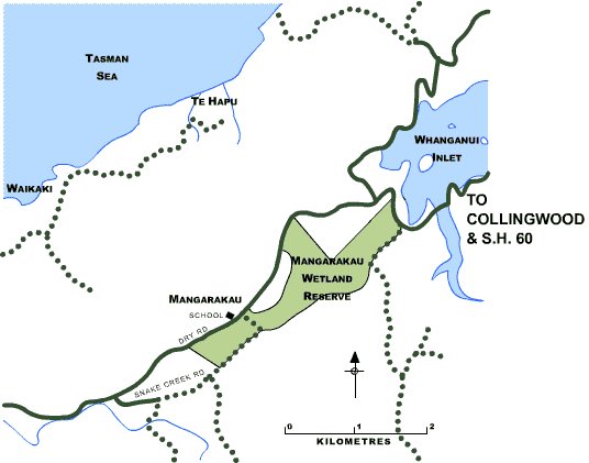
One of the Trust’s South Island Reserves, Mangarakau Wetland is located south of Farewell Spit. The wetland is immediately to the south of the Whanganui Inlet and drains into it as well as into the Patarau River further south.
History
A long history of human habitation pre-dates Abel Tasman, whose log records the first European sighting of New Zealand’s earliest settlers at Mangarakau . On 17th December 1642 “in the morning at the rising of the sun [we] were about 1 mile off the land, saw in various places smoke rise where fire was made by the inhabitants.” Since then there has been a sequence of extraction industries which have successively exhausted a natural resource. Gold, coal, timber, fishing and flax have all been thriving industries in the last 100 years. There was a large community of sawmillers in Mangarakau and a village that boasted many more facilities than exist today. Farming is now the main land use, but fishing and tourism are seen as the best long term prospects for the area. For more information about the wetland click here and for the latest newsletter click here.
Management
The reserve is managed by a local community group, Friends of Mangarakau Swamp. This dedicated group carries out restoration and maintenance work in the wetland and manages the use of the Lodge. From time to time they organise working bees and bring in people from further afield to assist with restoration work. If you would like to help with this work contact Robyn Jones on (03) 524 8266 or email mangarakauswamp@gmail.com. The reserve is fortunate to have few noxious or invasive weeds other than gorse, blackberry and some exotic tree species but these require constant work to keep them from re-establishing. While unpleasant, gorse can be a useful nurse crop for developing forests but is a nuisance where open wetland is desirable. Vigilance is required to prevent seeds of other pest species coming in on spades, boots and road maintenance equipment. Animal pests such as possums, pigs, rodents and mustelids are controlled. Tree planting and active restoration has been done using local seed grown off site and transplanted.
No hunting without the express permission of the Native Forest Restoration Trust
Vegetation
The wetland covers about 350 hectares, of which half is owned by the Department of Conservation. The Trust owns most of the balance. Within this area there are three dominant vegetation patterns. The Gleichenia fern/manuka scrublands are on the drier soils, while the wetter areas are covered in rush and reed communities of Typha (raupo) andBaumea . Within these areas there are some small lakes where the endangered Myriophyllum robustum continues to survive. The reedlands also have a some rare plants, including the pink Ladies’ Tresses Orchid (Spiranthes sinensis). There are some areas of planted exotic pines and Tasmanian blackwood which are being controlled.
The mature forest that once covered the wetland was Kahikatea and Pukatea-dominant, with a wide array of understorey species. Only a remnant now remains along the western edge, and this will be extended by planting.
Wildlife
Birds that favour open shrubland are common such as the pipit, Australasian harrier, welcome swallow, paradise shelduck, whitehead and silvereye. With so much mature forest nearby, the forest birds are gradually moving in – the tui, bellbird, kereru, grey warbler and cuckoo and, more recently, robins.
Special Values
The wetland is strategically located in the centre of a range of reserves. To the west the towering limestone bluffs are the dominant feature and most of the escarpment is secured as DOC’s scenic reserves. To the east the Kahurangi National Park extends into the Southern Alps and creates the backdrop and catchment for the wetland. Originally the waters drained through the wetland, then south to the Patarau River. Early settlers attempted to drain the northern area by creating drainage ditches flowing into the Whanganui Inlet, but this proved largely unsuccessful and it has always been too wet for pasture.
Facilities
The old community hall is all that remains from the forestry/farming days. The many sawmills and everything else has been demolished or burnt. Today a modern Lodge has been built on a central high point overlooking the wetland, and the old hall provides good accommodation for recreational visitors or tree planters. The farm and forestry roads have formed the basis for an excellent network of tracks through the reserve. The wet road is often impassable after heavy rain.
![]() For more detailed information about the use of the Lodge please click here.
For more detailed information about the use of the Lodge please click here.
How to Get There
Follow the main highway from Nelson through Motueka and over the Takaka Hill. Passing through Takaka, continue on past Collingwood to Pakawau. Take the left road that leads west then south, following around the eastern shore of Whanganui Inlet. Where the road leads around the southern end of the inlet the wetland is to your left, although mostly hidden by Manuka scrub and some exotic plantations. As you turn south again the wetland is visible to your left and the Trust Lodge and hall (2169 Dry Road) are just opposite the old school. Entry to the reserve is at your own risk.